《TAIPEI TIMES》 CWB issues a sea warning for Typhoon In-Fa
 ]
]
2021/07/22 03:00
/ Staff writer, with CNA
The Central Weather Bureau (CWB) at 8pm yesterday issued a sea warning for Typhoon In-Fa and said that a land warning might be issued today.
In-Fa was about 540km east-southeast of Taipei and was moving west at 8kph, the bureau said.
It had maximum sustained winds of 144kph, with gusts of up to 180kph, bureau data showed.
The international standard for a typhoon is maximum sustained winds of at least 119kph.
Given that In-Fa has been moving slowly, CWB forecaster Lin Ping-yu (林秉煜) said that the bureau is likely to issue a land warning today, either in the afternoon or in the evening.
Neither the CWB nor the US Navy’s Joint Typhoon Warning Center expect the eye of the storm to make landfall in Taiwan, forecasting that it would veer north and head toward China’s Zhejiang Province.
However, the typhoon would bring strong wind and heavy rain to northern Taiwan, including Yilan County, today and tomorrow, Lin said.
It would cause high waves along the east coast and Hengchun Peninsula, he said.
Meanwhile, Tropical Storm Cempaka is expected to weaken as it moves west, Lin said.
Cempaka made landfall in China’s Guangdong Province on Tuesday evening, the bureau said.
新聞來源:TAIPEI TIMES
Boats are docked yesterday at Nanfangao Harbor in Yilan County’s Suao Township as Typhoon In-Fa approaches Taiwan. Photo: Sam Yeh, AFP
不用抽 不用搶 現在用APP看新聞 保證天天中獎 點我下載APP 按我看活動辦法
Taiwan issues sea warning for Typhoon In-Fa
 ]
]
Update: 07/22 12:40 a.m.
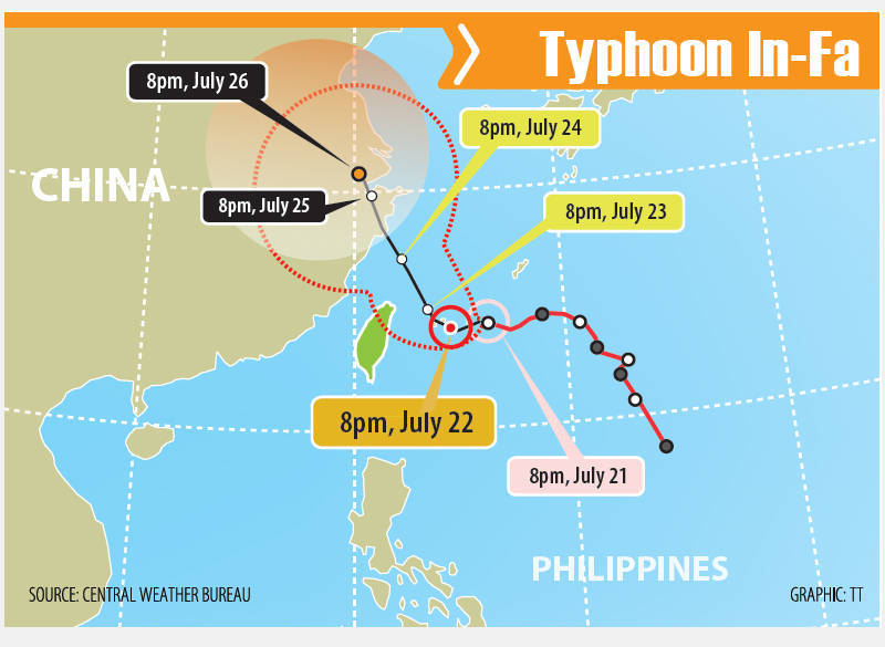
The CWB issued a sea warning for Typhoon In-Fa at 11:30 p.m. on Wednesday evening (July 21). As of 8 p.m. Wednesday, In-Fa was located 540 kilometers southeast of Taipei moving west-northwest at a speed of 6 kilometers per hour (kph). It had a radius of 200 km and was packing maximum sustained winds of 144 kph with gusts of up to 180 kph.
TAIPEI (Taiwan News) — As Typhoon In-Fa (烟花) intensifies and nears the waters off the coast of northeast Taiwan, the Central Weather Bureau (CWB) stated that it was planning on issuing a sea warning at 8:30 p.m. on Wednesday.
As of 2 p.m. on Wednesday, Typhoon In-Fa was located at 24.3 degrees north latitude and 127.1 degrees east longitude moving west-southwest at a speed of 11 kilometers per hour (kph). It had a radius of 180 km and was packing maximum sustained winds of 136 kph with gusts of up to 172 kph.
Satellite image of Typhoon In-Fa on July 21. (Windy.com image)
The CWB bureau on Wednesday afternoon announced that it would issue a sea warning for the typhoon at 8:30 p.m. that evening. CWB forecaster Lin Ping-yu (林秉煜) said that because the projected path for In-Fa has veered just to the north of Taiwan, the probability that it will make landfall in the country has diminished.
However, he said that the typhoon’s periphery will affect Taiwan from Thursday through Saturday (July 22-24). Lin predicted that the tropical cyclone will bring heavy rains on Thursday to northern Taiwan, localized rain to central and southern Taiwan, and afternoon thunderstorms to eastern Taiwan.
Lin said that In-Fa will come closest to Taiwan from Friday to Saturday when precipitation will be the most intense. Lin predicted that northern Taiwan could see as much as 200 millimeters of rain per day, while central Taiwan and Yilan could also see heavy downpours, with brief showers and thunderstorms likely in the rest of the country.
Typhoon In-Fa periphery to bring heavy rain to northern Taiwan today
 ]
]
TAIPEI (Taiwan News) — The Central Weather Bureau (CWB) this morning (July 22) issued extremely heavy wind and heavy rain advisories for nine counties and cities in northern and western Taiwan as the periphery of Typhoon In-Fa (烟花) approaches.
As of 8 a.m. today, In-Fa was located 490 kilometers southeast of Taipei and moving west-northwest at a speed of 5 kilometers per hour, according to the CWB. It had a radius of 200 km and was packing maximum sustained winds of 144 kph with gusts of up to 180 kph.
With the periphery of Typhoon In-Fa beginning to reach Taiwan, the CWB at 9:35 a.m. released an extremely heavy rain advisory for Taipei City, New Taipei City, Taoyuan City, Hsinchu County, Miaoli County, and Yilan County. It also issued a heavy rain advisory for Keelung City, Hsinchu City, and Taichung City.
Map of Typhoon In-Fa’s predicted path. (JTWC image)
CWB forecaster Hsieh Pei-yun (謝佩芸) said that as In-Fa nears Taiwan today, its outer rain bands will affect the western and northern parts of the country. She predicts there will be heavy rainfall in the north and northeast, including mountainous areas, while central and southern Taiwan will see scattered showers that will increase in intensity later in the day.
In addition to precipitation, Hsieh said In-Fa’s periphery will also bring powerful winds and big waves to coastal areas of the north and northeast, the Taiwan Strait, the Hengchun Peninsula, and Matsu. Waves as high as 5 meters have been reported on the coast of Matsu, while waves up to 3 meters in height have been seen on Taiwan’s east coast.
Map of In-Fa’s predicted path. (JMA image)
Hsieh said that In-Fa is moving very slowly and that due to high water temperatures, there are still opportunities for it to intensify before it is at its closest. Based on current models, Hsieh says it appears that In-Fa will swing north-northwest and pass between Japan’s Miyako-jima and Ishigaki on Friday morning (July 23).
Hsieh predicted that In-Fa will be closest to Taiwan Friday and Saturday (July 24). Therefore, Hsieh said that the impact on the country in terms of wind and rain will be even greater over the coming two days.
Map of In-Fa’s predicted path. (CWB image)
By Sunday (July 25), In-Fa will have shifted far from Taiwan as it begins to make landfall in China’sZhejiang Province. Starting on Sunday, Taiwan will be affected by southwesterly winds, which are expected to bring more precipitation well into next week.
Animated GIF of Typhoon In-Fa. (NOAA image)