Hurricane, tropical storm or super typhoon? Here is what to know about Taiwan’s most dangerous weather systems
 ]
]
【看CP學英文】颱風是一個具有破壞性的風暴。大西洋另一端稱之為「颶風」的颱風,在亞太地區最常於七月到十月間侵襲台灣。
A typhoon is a storm of damaging proportions. Also known as hurricanes across the Atlantic Ocean, the most dangerous weather systems in the Asia-Pacific region are most likely to hit Taiwan from July to October.
然而,熱帶性低氣壓和超級颱風的差別到底是什麼?
But, what’s the difference between tropical depressions and super typhoons?
亞太地區有四種類型的的破壞性暴風。它們與地震不同在於它們一定程度的可預測性。
There are four types of destructive storms in the Asia-Pacific region which, unlike earthquakes, are somewhat predictable.
風速每小時29英理(46公里)以下的稱之為「熱帶性低氣壓」;風速在每小時29英里(46公里)和每小時55.5英里(89公里)之間的稱之為「熱帶風暴」或「熱帶氣旋」。而又稱之為颶風的颱風則是風速在每小時55.5英里(89公里)和每小時114.5英里(183公里)之間的風暴。
The tropical depressions — wind speeds of 29 mph (46 kph) or less; the tropical storms — wind speeds between 29 mph (46 kph) and 55.5 mph (89 kph); and, the typhoons, also known as hurricanes — wind speeds between 55.5 mph (89 kph) and 114.5 mph (183 kph).
超級颱風,相當於第五類風暴,因為其風速超過114.5英里/小時(183公里/小時)。
Super Typhoons, which are equivalent to a category 5 storm, have wind speeds greater than 114.5 mph (183 kph).
除了帶來破壞力強大的巨風外,颱風還能降下難以置信的雨量。由於台灣島的山脈縱貫全島,這些風暴的降雨量有時會在數個月中超過常規降雨量。
In addition to bringing damaging winds, typhoons can drop incredible amounts of rain. Owing to the mountains running the length of the island, these storms can sometimes drop rain in excess months of regular precipitations.
颱風來了該怎麼辦?|What should you do in case of a typhoon?
前往此網頁以獲取更多璨樹颱風相關資訊。
Visit this page for the latest information about Typhoon Chanthu.
The China Post也會將氣象局的播報資訊及警訊附在臉書粉絲團上。
The China Post will broadcast the advisories and warnings as they are updated by the Central Weather Bureau on its Facebook page.
淹水和土石流等現象有時毫無預警的發生。如果該地區有收到警訊,請立即疏散。
Flooding and landslides can occur with very little warning. If an advisory is issued for your area, please take immediate action.
應該準備什麼?|What should you prepare?
颱風來襲,你應該在家中準備好一個緊急災難包,裡面應當有急救箱和基本藥物。
In case of a typhoon, you should prepare a disaster supplies kit for home, including a first aid kit and essential medications.
台灣災難醫療隊建議民眾備好足夠維持至少一天的食物量、水、電池和其他應急用品。
Disaster preparedness officials recommend that you have enough food, water, batteries, and other emergency supplies to last at least 1 day.
在斷水的情况下,可以考慮到附近的便利商店買可飲用的水和一些泡麵。
In case of water cuts, think of rushing to a convenience store next door to buy some drinkable water and some instant noodles.
還剩下什麼呢?|What’s more?
記得將電器產品充飽電,多儲備可飲用水和電池,同時也別忘記為車子加好油(以防萬一)。同時,你也可以將家裡的浴缸先裝滿水以備不時之需。
Remember to charge up electronics, secure extra water and batteries, and fill up your car ahead of the weekend. You can also run a bathtub full of water for a large supply of emergency water, in case the water supply is interrupted.
颱風很危險不只因為它們可以造成身體傷害和財產損失;強風還可能擊倒電線和中斷水的供應。
Typhoons are dangerous not only because they can cause bodily injury and damage to property, but strong winds can also knock down power lines and disrupt the water supply.
另外,以防斷電時冰箱無法保持低溫,可以事先將寶特瓶裝滿水冰在其中,斷電時,就可以當大冰塊保持食物新鮮。
One way to keep the contents of your fridge cool in a power blackout is to freeze PET bottles of water in advance and use these as ice blocks.
Flights disrupted as Typhoon Chanthu approaches Taiwan
 ]
]
Taiwan issues land warning for Super Typhoon Chanthu
 ]
]
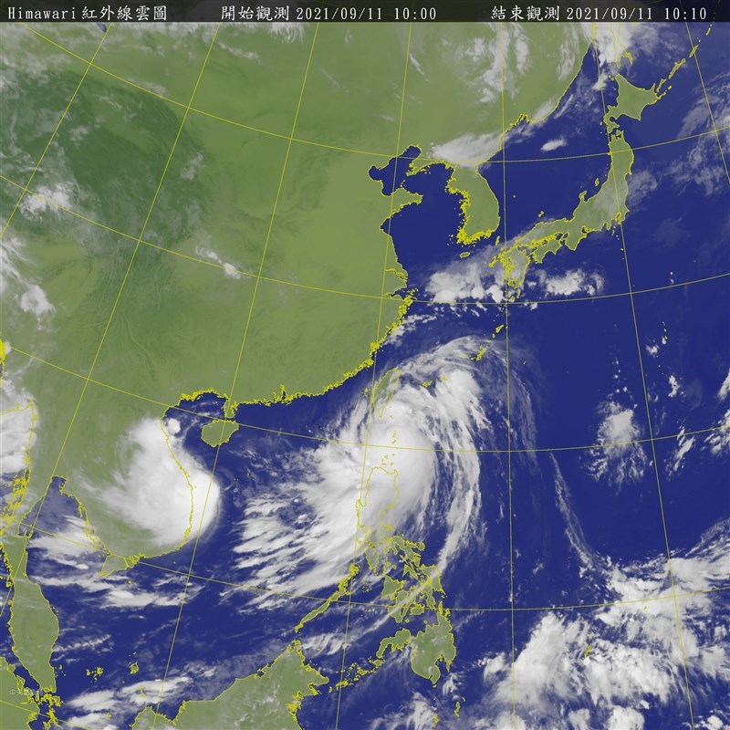
TAIPEI (Taiwan News) — The Central Weather Bureau (CWB) at 5:30 p.m. on Friday (Sept. 10) evening issued a land warning for Super Typhoon Chanthu (璨樹), just 12 hours after it issued a sea warning at 5:30 a.m.
At 2 p.m., Typhoon Chanthu was about 530 kilometers south-southeast of Taiwan’s southernmost tip of Eluanbi, moving north-northwest at a speed of 17 kilometers per hour. It had a radius of 200 km and was packing maximum sustained winds of 208 kph and gusts of up to 262 kph, the CWB reported.
In its sea warning, the CWB announced the mega cyclone’s eye wall is approaching the Bashi Channel and posing a threat to the Bashi Channel, the waters off the coast of southeastern Taiwan, and the southern part of the Taiwan Strait. Because the weather bureau believes the storm is also increasingly likely to pose a threat to Taiwan’s land, it issued a land warning at 5:30 p.m. for Pingtung County and Taitung County.
Sea and land warning issued for Super Typhoon Chanthu. (CWB image)
The CWB predicts that as the typhoon closes in on Taiwan, its periphery will begin to impact the country Friday evening, bringing rain to eastern Taiwan. Rain and wind will intensify on Saturday (Sept. 11), when heavy rains are likely in eastern Taiwan, Keelung City, and the Hengchun Peninsula.
On Saturday, residents of all parts of Taiwan should take precautions against strong winds and torrential rains. The most intense areas of precipitation will likely be central and northern Taiwan, Yilan County, Hualien County, and mountainous areas, especially in northern and eastern Taiwan, where torrential rains are probable.
CWB forecasters are currently unable to determine the storm’s precise path over the weekend. However, CWB forecaster Hsu Chung-yi (徐仲毅) said waves will gradually increase in height in the Bashi Channel and waters off southeastern Taiwan.
He added there will be large waves off the coast of Keelung, eastern Taiwan (including Orchid Island and Green Island), the central and southern regions, the Hengchun Peninsula, Penghu, and Kinmen. Hsu warned people to exercise extreme caution near coastal areas.
Map of Typhoon Chanthu’s projected path. (CWB image)
Wind radii probability map for Chanthu and Conson. (CWB image)
Map of Typhoon Chanthu’s projected path. (JTWC image)
Map of Typhoon Chanthu’s projected path. (JMA image)
(Windy image)