Forecasters: Tropical Storm Nicholas forms in Gulf of Mexico
 ]
]
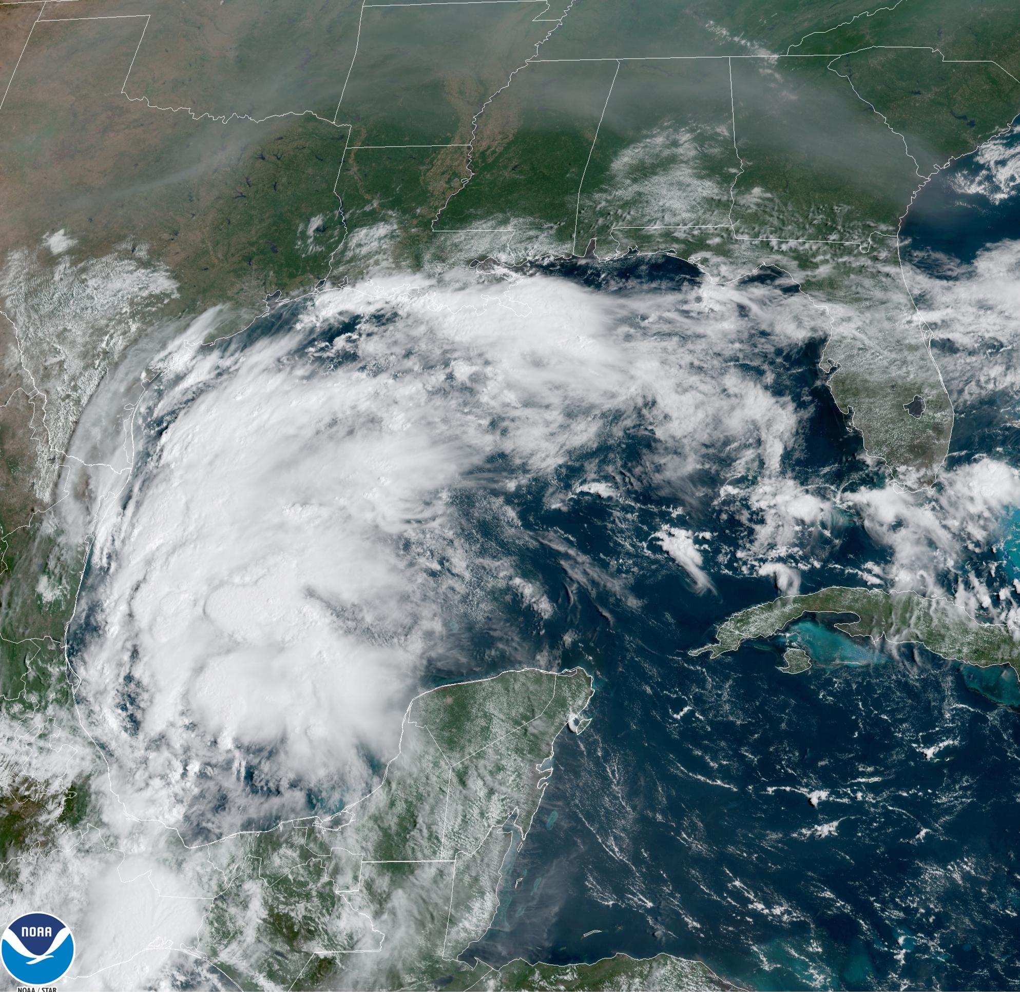
This satellite image provided by NOAA shows Tropical Storm Nicholas in the Gulf of Mexico on Sunday, Sept. 12, 2021. Tropical storm warnings have been issued for coastal Texas and the northeast coast of Mexico. Nicholas is expected to produce storm total rainfall of 5 to 10 inches, with isolated maximum amounts of 15 inches, across portions of coastal Texas into southwest Louisiana Sunday, Sept. 12 through midweek. (NOAA via AP)
This satellite image provided by NOAA shows Tropical Storm Nicholas in the Gulf of Mexico on Sunday, Sept. 12, 2021. Tropical storm warnings have been issued for coastal Texas and the northeast coast of Mexico. Nicholas is expected to produce storm total rainfall of 5 to 10 inches, with isolated maximum amounts of 15 inches, across portions of coastal Texas into southwest Louisiana Sunday, Sept. 12 through midweek. (NOAA via AP)
MIAMI (AP) — Tropical Storm Nicholas was expected to strengthen as it headed for the Gulf Coast on Sunday, threatening heavy rain and floods in coastal areas of Texas, Mexico and Louisiana.
Forecasters at the National Hurricane Center in Miami said a hurricane watch and storm surge warning were issued for a portion of Texas, while tropical storm warnings were issued for coastal areas of Texas. Nicholas is expected to produce total rainfall of 5 to 10 inches (13 to 25 centimeters), with isolated maximum amounts of 15 inches, across portions of coastal Texas into southwest Louisiana on Sunday through midweek. The hurricane watch was issued for the coast of Texas from Port Aransas to Sargent.
The storm was expected to bring the heaviest rainfall west of where Hurricane Ida slammed into Louisiana two weeks ago . Although forecasters did not expect Louisiana to suffer from strong winds again, meteorologist Bob Henson at Yale Climate Connections predicted rainfall could still plague places where the hurricane toppled homes, paralyzed electrical and water infrastructure and left at least 26 people dead.
“There could be several inches of rain across southeast Louisiana, where Ida struck,” Henson said in an email.
Across Louisiana, 140,198 customers — or about 6.3% of the state — remained without power on Sunday morning, according to the Louisiana Public Service Commission.
Louisiana Gov. John Bel Edwards took to Twitter to urge people in the southern portion of the state to keep a close eye on the storm and be prepared for heavy rains and flash flooding.
The storm is projected to move slowly up the coastland which could dump torrential amounts of rain over several days, said meteorologist Donald Jones of the National Weather Service in Lake Charles, Louisiana.
“Heavy rain, flash flooding appears to be the biggest threat across our region,” he said in an email.
The storm has the potential to dump as much as 15 to 25 inches (38 to 64 centimeters) of rain in isolated areas either in southeast Texas or southwest Louisiana, he said.
While Lake Charles received minimal impact from Ida, the city saw multiple wallops from Hurricane Laura and Hurricane Delta in 2020, a winter storm in February as well as historic flooding this spring.
“We are still a very battered city,” Lake Charles Mayor Nic Hunter said.
He said the city is taking the threat of the storm seriously, as it does all tropical systems.
“Hope and prayer is not a good game plan,” Hunter said.
At 4 p.m. EDT, the center of the storm was forecasted to pass near or just offshore the coasts of northeastern Mexico and South Texas on Monday, and hit south or central Texas on Monday night or early Tuesday. Its maximum sustained winds were clocked at 40 mph (65 kph) and it was moving north-northwest at 15 mph (24 kph). Gradual strengthening is forecast in the next day or so.
Texas Gov. Greg Abbott placed rescue teams and emergency medical groups on standby along the length of the Texas Gulf Coast.
“We will continue to closely monitor this storm and take all necessary precautions to keep Texans safe,” Abbott said in a statement. “I encourage Texans to follow the guidance and warnings of their local officials and be mindful of potential heavy rain and flooding.”
Colorado State University hurricane researcher Phil Klotzbach said via Twitter that Nicholas is the 14th named storm of 2021 Atlantic hurricane season. Only 4 other years since 1966 have had 14 or more named storms by Sept. 12: 2005, 2011, 2012 and 2020.
Houston area prepares for Tropical Storm Nicholas
 ]
]
Galveston County Judge Mark Henry said they are expecting between 15 and 20 inches of rain in some areas.
GALVESTON COUNTY, Texas — All eyes are on Tropical Storm Nicholas as in churns in the Gulf of Mexico. The current track has it heading toward Southeast Texas.
Local leaders are asking people to be weather-ready. While the direct impacts of Nicholas are yet unknown, officials across the region said the time to prepare is before the storm actually hits.
Galveston County
In Galveston County, businesses blocked storefronts with sandbags ahead of potential flooding. Judge Mark Henry said the county is expecting between 15 and 20 inches of rain in some areas. He said there’s low confidence in the exact track of the storm and its impact.
“They’re not really sure where exactly where the rain is going to fall so we have to be prepared for all the 20 inches to fall right here in Galveston County,” Henry said.
The Galveston Beach Patrol spent part of Sunday moving towers and clearing the sand.
“Everything’s handled so when we do need to have our rescue people out there making revues or doing preventative actions they’re able to really focus on that,” Galveston Beach Patrol Chief Peter Davis said.
The Galveston County Office of Emergency Management has deployed its high-water assets.
“A lot of tropical storms produce a lot of rain for us. And that’s really the big threat," Emergency Management Coordinator Scott Tafuri said.
Meteorologist Larry Perez and his team at Saltwater Recon have 25 cameras on the island. As a Galveston native, Perez knows a storm surge combined with rain could be problematic for the island.
“It’s mainly going to be how much coastal flooding we get and how much rain we get on top of that … might cause serious disruptions within the downtown area particularly,” Perez said.
Houston
Houston Mayor Sylvester Turner said crews are positioning barricades around the city in low-lying areas.
“Please be weather aware … Monday, Tuesday, and going into Wednesday,” Turner said. “Don’t drive through water especially at nighttime because you don’t know how deep that water can be.”
He said the threat of heavy rain can be triggering but he doesn’t want people to be caught unprepared.
“Just because you don’t hear ‘hurricane,’ … it could be a system developing in the Gulf and what we have seen these systems can really accelerate very, very quickly,” Turner said.
The city will be activating its office of emergency management on Monday. Officials want people to take the threat of severe weather seriously.
Harris County Meteorologist Jeff Linder said Nicholas’ impact is still unpredictable.
“Anywhere from 10 to 15 inches (of rain) is possible with highest 20 inches,” Lindner said. “Be prepared for flooding, especially street flooding, and even the potential for some bayou and creek flooding.”
Tropical Storm Nicholas in the Western Gulf a Major Rainfall Flood Threat For Texas, Louisiana
 ]
]
At a Glance Tropical Storm Nicholas is expected to strengthen in the western Gulf of Mexico.
Heavy rain and flash flooding are a major concern in parts of Texas and Louisiana.
Strong wind gusts and storm surge are also expected near the coast. Tropical Storm Nicholas in the western Gulf of Mexico will be a major rainfall flood threat to parts of the Texas and Louisiana coasts, in addition to strong wind gusts and storm surge.
Nicholas is centered about 250 miles south-southeast of the border between Texas and Mexico. It’s helping to produce widespread showers and thunderstorms throughout a broad area of the western Gulf of Mexico right now. Some bands of rain associated with Nicholas have already spread into the Texas and Louisiana coasts.
Current Radar, Watches and Warnings
Tropical storm warnings have been issued along the coast of Texas from the mouth of the Rio Grande River to High Island, as well as some inland counties near the Texas coast and the southeast Houston metro area. This means tropical-storm-force winds (39+ mph) are expected in these areas beginning as soon as Monday morning farther south and Monday night farther north.
A hurricane watch is also now in effect for a part of the middle Texas coast, from Port Aransas to Freeport. Hurricane conditions could occur in this area by Monday night.
A tropical storm watch is in effect on the Texas coast from east of High Island to Sabine Pass, and also for some inland counties including Harris County and the city of Houston. These areas could see tropical-storm-force winds by late Monday night or early Tuesday.
Watches and Warnings (A watch is issued when tropical storm conditions are possible within 48 hours. A warning is issued when those conditions are expected within 36 hours. )
The National Hurricane Center expects Nicholas to track northward near or just off the coasts of northeast Mexico and Texas through early this week, as depicted by the forecast path in the map below.
Nicholas is forecast to strengthen into a moderate to strong tropical storm as it makes this general track. Landfall should happen sometime Monday afternoon into Tuesday.
A track on the right side of the forecast path could allow Nicholas to stay over water longer and become a Category 1 hurricane. That’s why a hurricane watch is now in effect for a part of the middle Texas coastline.
It’s important to note that impacts, especially flooding rain, will occur both well before and after any official landfall happens.
Projected Path, Intensity Forecast (The red-shaded area denotes the potential path of the center of the tropical cyclone. It’s important to note that impacts (particularly heavy rain, high surf, coastal flooding, winds) with any tropical cyclone usually spread beyond its forecast path. )
Here’s a look at the expected forecast impacts from Nicholas.
Forecast Impacts
Flooding Rainfall
The potential for flooding rainfall will be the most widespread threat from Nicholas, regardless of how much it strengthens.
Bands of locally heavy rain are beginning to wrap ashore into the Texas and Louisiana coasts as a surge of deep moisture arrives. That wet pattern might last for several days through at least the first half of this week.
Heavier rain will also become more concentrated near and just to the east of where the center of Nicholas tracks along the western U.S. Gulf Coast.
Therefore, we expect a major threat of flash flooding near the Gulf Coast from Texas to southwest Louisiana through the first half of the week.
Nicholas could produce the following rainfall totals along its path through midweek, according to NOAA’s Weather Prediction Center.
-8 to 16 inches (locally up to 20 inches) across parts of the middle and upper Texas coast.
-5 to 10 inches across the rest of coastal Texas into southwest Louisiana.
The potential for flooding could be worsened in some areas if Nicholas slows its northward progress for a time, as some forecast models indicate.
Advertisement At least some bands of heavier rain might also swing inland over southeastern Louisiana and southern Mississippi – areas still recovering from Hurricane Ida.
Rainfall Forecast (This should be interpreted as a broad outlook of where the heaviest rain may fall and may shift based on the forecast path of the tropical system. Higher amounts may occur where bands of rain stall over a period of a few hours. )
Flash flood watches have been issued by the National Weather Service for this threat of heavy rain, from southwest Louisiana to all of coastal Texas. This includes Houston and Corpus Christi in Texas and Lake Charles in Louisiana.
Do not drive through floodwaters of any depth and be sure to stay aware of the latest forecast and warning information if you live in a flood-prone location.
NOAA’s Weather Prediction Center said Sunday afternoon that flooding rainfall could “lead to significant damage and life-threatening situations” in some areas.
Flood Alerts (From the National Weather Service.)
Wind
Nicholas could produce tropical-storm-force winds within the warning and watch areas along and near the Texas coast Monday into Tuesday.
Stronger wind gusts might cause some tree damage and scattered power outages in spots. The winds could also down some trees, especially where soil become saturated from Nicholas’ heavy rain.
Storm Surge
Onshore winds are also likely to lead to dangerous rip currents and push water toward parts of the Texas and southwestern Louisiana coasts.
Storm surge is predicted to be the following heights above normal tide levels if the peak surge occurs at the time of high tide, according to the NHC.
-3 to 5 feet from Port O’Connor, Texas, to San Luis Pass, Texas, including Matagorda Bay.
-2 to 4 feet from the Mouth of the Rio Grande to Port O’Connor, Texas.
-2 to 4 feet from San Luis Pass, Texas, to Rutherford Beach, Louisiana, including Galveston Bay.
-2 to 4 feet in Baffin Bay, Corpus Christi Bay, Aransas Bay and San Antonio Bay.
-1 to 3 feet from Rutherford Beach, Louisiana, to Intracoastal City, Louisiana, including Sabine Lake and Calcasieu Lake.
These peak surge values may occur in the hours before and after the center of Nicholas moves ashore especially along and to the east of the center.
Tornadoes
As often is the case with landfalling storms, a few tornadoes are possible in Nicholas’ rainbands, generally to the north and northeast of the center from later Monday into at least early Tuesday along and near the middle and upper Texas coasts.
Check back frequently for the latest on this situation as it develops.
The Weather Company’s primary journalistic mission is to report on breaking weather news, the environment and the importance of science to our lives. This story does not necessarily represent the position of our parent company, IBM.