Typhoon Chanthu likely to reach Taiwan on September 11 氣象局預估璨樹極可能侵台 於週六下半天登陸 | 公視新聞網 PNN
 ]
]
Chanthu is “very likely” to end Taiwan’s streak of having no typhoon during the last few years.
Presenter: Typhoon Chanthu is very likely to become one of the few strong typhoons that hit Taiwan directly. It will be closest to the island over the weekend. Some experts say they see similarities between Typhoon Chanthu and Super typhoon Nepartak in 2016, which caused one death and a loss of nearly NT$ 100 million.
Two whale-watching ships take advantage of the good weather on the 10th to set sail, ahead of the arrival of Typhoon Chanthu.
Chiu Hsi-tung, Whale-watching Tour Operator:”We won’t be able to go out to sea starting this afternoon, and probably not tomorrow or the day after either.”
The Central Weather Bureau issued a sea typhoon warning at 5:30 a.m. on the 10th. Whether Chanthu will strike Taiwan directly is still uncertain.
Hsu Chung-yi, Forecaster, Central Weather Bureau:”Its forecasted route has not changed and we expect to issue both sea and land typhoon warnings later today. Eastern, northern and southern Taiwan will be affected the most.”
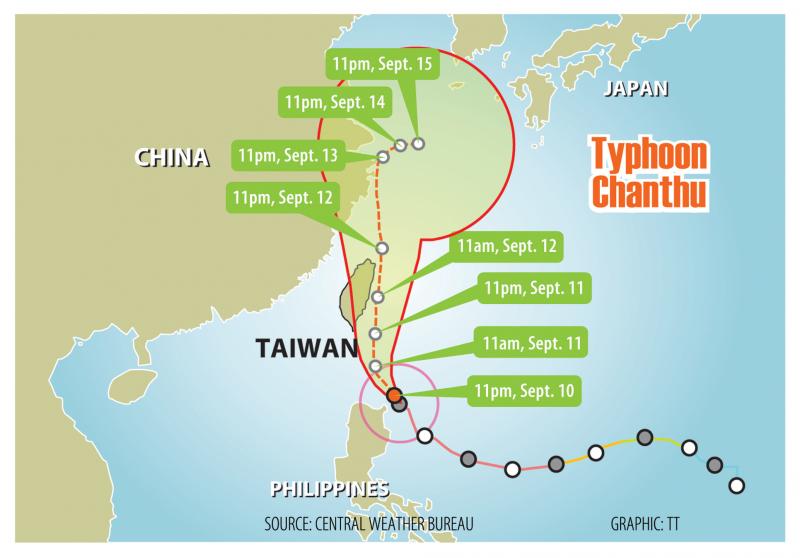
The bureau says it will issue a land warning 18 hours before the typhoon makes landfall. Chanthu will be closest to Taiwan on the 11th and 12th, affecting eastern, northern, and parts of southern Taiwan. Very few typhoons have hit Taiwan directly in the last few years. The last one to get so close was Typhoon Nepartak in 2016, which caused agricultural losses of NT$960 million.
Peng Chi-ming, CEO, Weatherrisk:”We haven’t seen such a strong typhoon coming towards Taiwan in a very long time. It may weaken as it gets closer to Taiwan, but it will still be at least a medium-strength typhoon.”
Based on Chanthu’s current path, it will make landfall somewhere between Yilan or Hualien. Chanthu’s storm circle will encircle all of Taiwan, with heavy rain forecasted islandwide especially in eastern Taiwan. Work and classes may be suspended on the 12th in eastern and northern Taiwan
週五一早風和日麗、艷陽高照,花蓮港兩艘賞鯨船,趁著好天氣,“璨樹"颱風入境前出港,10號下午就不再出海,準備綁船固定防颱作業。
賞鯨船業者 邱錫棟:「今天我們預計下午的航班,可能就開始做停航的動作。那明後天兩天那基本上也是在停航的狀態。」
10號清晨5點30分,中央氣象局發布海上颱風警報,至於颱風是否登陸,變數仍大。
中央氣象局預報員 徐仲毅:「就是預報路徑沒有變數,我們預計在今天的下午到晚間有可能發布陸上的,海上陸上颱風警報影響比較大的區域,大概是我們東半部北部地區跟南部的部份地區,會受到比較大的影響。」
氣象局表示,可在颱風登陸前18個小時,就預警性發布"陸警”,預估週六及12號週日最靠近台灣。主要影響範圍東半部、北部及部分南部地區。氣象專家表示,近幾年來已經很少有強颱侵襲台灣,最近一次強颱,是2016年尼伯特颱風,當時造成農作物損失超過9.6億。這次璨樹如果登陸,強大風雨對台影響大。
天氣風險管理公司 彭啟明:「我們很久沒有經歷過一個強烈颱風侵襲台灣,當然它接近台灣的時候,有可能會稍微減弱一點點,大概是中颱上限接近強颱的下限這樣的一個幅度。」
氣象專家表示,預估璨樹路徑,會貼著台灣東部外海走,依照過去經驗,只要接近東部外海,環流受地形,特別是中央山脈,產生交互作用,屆時可能在花蓮,或往北一點宜蘭附近登陸,基本上全台,都有機會被暴風圈籠罩,有顯著降雨,東半部首當其衝,預估六日影響最大,預估週日,東半部地區、及北部地區有停班停課機率。
Taiwan issues sea warning for Super Typhoon Chanthu
 ]
]
TAIPEI (Taiwan News) — The Central Weather Bureau (CWB) at 5:30 a.m. Friday morning (Sept. 10) issued a sea warning for Super Typhoon Chanthu (璨樹), and it is likely to issue a land warning in the afternoon as the storm picks up speed.
As of 8 a.m., Typhoon Chanthu was about 630 kilometers southeast of Taiwan’s southernmost tip of Eluanbi, moving northwest at a speed of 19 kilometers per hour. It had a radius of 180 km and was packing maximum sustained winds of 190 kph and gusts of up to 234 kph, the CWB reported.
CWB forecaster Hsu Chung-yi (徐仲毅) said that if there is no change to the predicted path of the typhoon, the bureau will issue a land warning this afternoon. Hsu predicted that Chanthu will come closest to Taiwan on Saturday and Sunday (Sept. 11 and 12).
Sea warning issued for Super Typhoon Chanthu. (CWB image)
During that period, Hsu said that the mega cyclone will bring powerful winds and torrential rains throughout the country. He pointed out that because there will be mid- to high-tides for the next two days, people in low-lying areas should beware of flooding.
As for whether the typhoon will make landfall in Taiwan, Hsu said that based on its current path, the eye of the storm will pass through the waters off the east coast. However, this trajectory could easily shift west depending on the strength of a high-pressure ridge, and variability in the typhoon’s movements is still high.
Hsu said that during the day today, waves will gradually increase in height in the Bashi Channel and waters off southeastern Taiwan. He added that there will be large waves off the coast of Keelung, eastern Taiwan (including Orchid Island and Green Island), the central and southern regions, the Hengchun Peninsula, Penghu, and Kinmen. Hsu warned people to exercise extreme caution near coastal areas.
Map of Typhoon Chanthu’s projected path. (CWB image)
Wind radii probability map for Chanthu and Conson. (CWB image)
(JMA image)
(Windy image)
(NOAA image)
(CWB image)
(NOAA image)
Typhoon Chanthu spurs land warning
]
Typhoon Chanthu spurs land warning
CAUTION URGED: Strong winds and heavy rain are forecast throughout the nation, even though the CWB was not sure whether the eye would make landfall in Taiwan
Staff writer, with CNA
The Central Weather Bureau (CWB) yesterday issued a land warning for Typhoon Chanthu, as it continued to gain power while approaching Taiwan from the southeast.
As of 8pm last night, Chanthu was about 410km southeast of Pingtung County’s Oluanpi (鵝鑾鼻), the southernmost point of Taiwan proper, moving northwest at 15kph toward the Bashi Channel.
The typhoon had maximum sustained winds of 209kph, with gusts of up to 263kph, bureau data showed.
Chanthu, which is likely to come closest to the nation over the weekend, could pose a threat throughout Taiwan proper, but particularly in Taitung and Pingtung, the bureau said.
Strong winds and heavy rainfall are forecast throughout the nation tomorrow, it said.
It was unclear whether Chanthu’s eye would make landfall, as that would depend on a Pacific high-pressure system, it said.
Fishing boats are moored in the harbor of Pingtung County’s Donggang Township yesterday as Typhoon Chanthu was moving toward Taiwan from the southeast. Photo: CNA
However, based on the storm’s trajectory yesterday afternoon, it is likely that Chanthu’s center would skirt eastern Taiwan as it heads north, forecasters said.
Food delivery service providers Uber Eats Taiwan and Foodpanda Taiwan Co (富胖達) said that no services would be offered should the government require office closures.
As of press time last night, Taitung County’s Lanyu (蘭嶼) and Green Island (綠島) townships had declared today a typhoon day, canceling work and classes.
In anticipation of Chanthu, ferries serving Taitung County, Pingtung County, Orchid Island (Lanyu) and Green Island were suspended for yesterday and today.
The Taitung County Government ended its annual hot air balloon festival early on Thursday, citing Chanthu and the COVID-19 situation.
The festival, which was originally scheduled to take place from July 3 to Aug. 8, opened on Aug. 14 due to a level 3 COVID-19 alert and was to end on Sunday.
Average wholesale vegetable prices in Taipei rose to NT$48 per kilogram, Council of Agriculture data showed yesterday.
Vegetable prices would likely fall after Chanthu passes, dropping to under NT$35 next month, Agricultural and Food Agency Deputy Director-General Yao Chih-wang (姚志旺) said.