Flights disrupted as Typhoon Chanthu approaches Taiwan
 ]
]
Taiwan issues land warning for Super Typhoon Chanthu
 ]
]
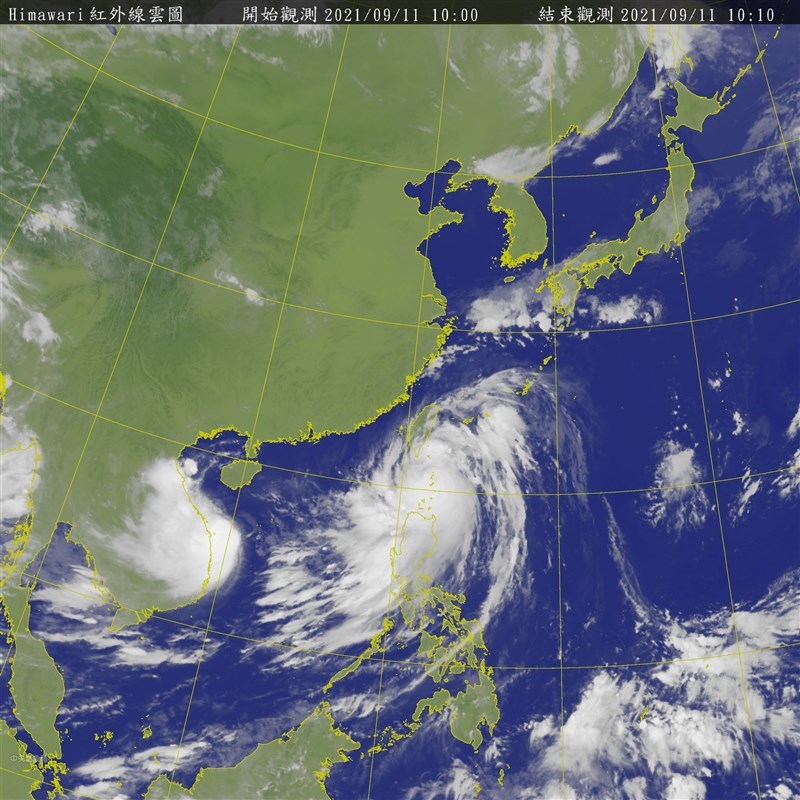
TAIPEI (Taiwan News) — The Central Weather Bureau (CWB) at 5:30 p.m. on Friday (Sept. 10) evening issued a land warning for Super Typhoon Chanthu (璨樹), just 12 hours after it issued a sea warning at 5:30 a.m.
At 2 p.m., Typhoon Chanthu was about 530 kilometers south-southeast of Taiwan’s southernmost tip of Eluanbi, moving north-northwest at a speed of 17 kilometers per hour. It had a radius of 200 km and was packing maximum sustained winds of 208 kph and gusts of up to 262 kph, the CWB reported.
In its sea warning, the CWB announced the mega cyclone’s eye wall is approaching the Bashi Channel and posing a threat to the Bashi Channel, the waters off the coast of southeastern Taiwan, and the southern part of the Taiwan Strait. Because the weather bureau believes the storm is also increasingly likely to pose a threat to Taiwan’s land, it issued a land warning at 5:30 p.m. for Pingtung County and Taitung County.
Sea and land warning issued for Super Typhoon Chanthu. (CWB image)
The CWB predicts that as the typhoon closes in on Taiwan, its periphery will begin to impact the country Friday evening, bringing rain to eastern Taiwan. Rain and wind will intensify on Saturday (Sept. 11), when heavy rains are likely in eastern Taiwan, Keelung City, and the Hengchun Peninsula.
On Saturday, residents of all parts of Taiwan should take precautions against strong winds and torrential rains. The most intense areas of precipitation will likely be central and northern Taiwan, Yilan County, Hualien County, and mountainous areas, especially in northern and eastern Taiwan, where torrential rains are probable.
CWB forecasters are currently unable to determine the storm’s precise path over the weekend. However, CWB forecaster Hsu Chung-yi (徐仲毅) said waves will gradually increase in height in the Bashi Channel and waters off southeastern Taiwan.
He added there will be large waves off the coast of Keelung, eastern Taiwan (including Orchid Island and Green Island), the central and southern regions, the Hengchun Peninsula, Penghu, and Kinmen. Hsu warned people to exercise extreme caution near coastal areas.
Map of Typhoon Chanthu’s projected path. (CWB image)
Wind radii probability map for Chanthu and Conson. (CWB image)
Map of Typhoon Chanthu’s projected path. (JTWC image)
Map of Typhoon Chanthu’s projected path. (JMA image)
(Windy image)
Super Typhoon Chanthu and Tropical Storm Conson to make landfall this weekend
 ]
]
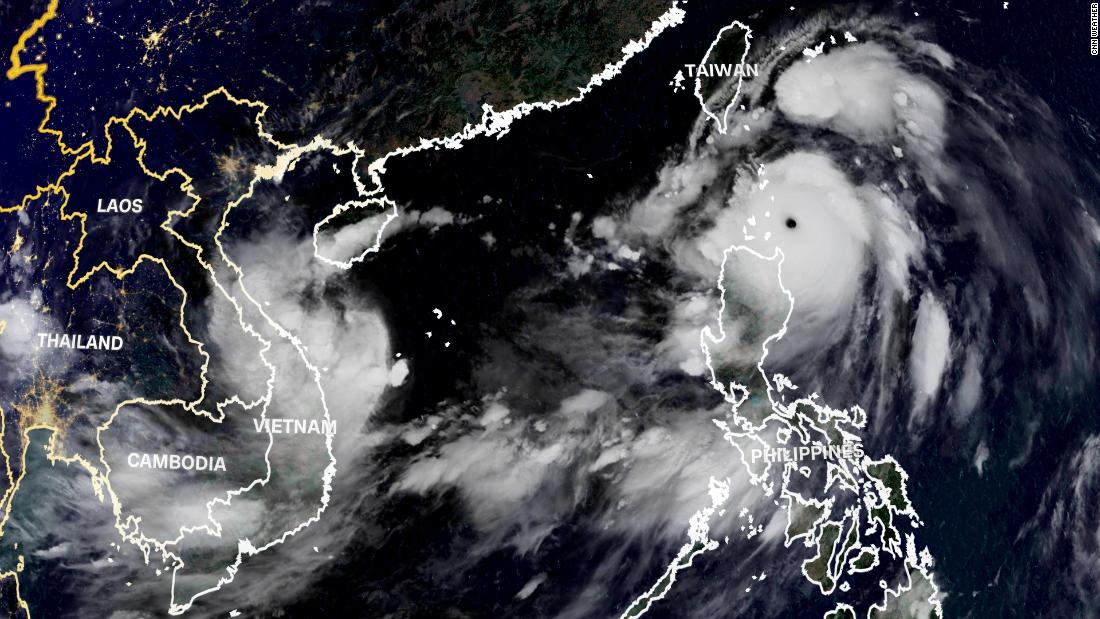
Hong Kong (CNN) Vietnam and Taiwan are bracing for powerful twin storms which are expected to make landfall over the weekend.
Super Typhoon Chanthu is expected to bring damaging winds and extremely heavy rainfall to Taiwan, while Tropical Storm Conson is forecast to bring flooding rains to Vietnam.
Taiwan issued a sea and land warning for Pingtung and Taitung Country on Friday ahead of Super Typhoon Chanthu . Chanthu is one of the strongest storms this year, with sustained winds of 260 kph (160 mph) as of Friday evening – equivalent in strength to a Category 5 Atlantic hurricane.
Chanthu formed on September 6, according to the Joint Typhoon Warning Center. The storm then underwent one of the most extreme bouts of rapid-intensification ever recorded, by increasing 80 knots in wind speed in just 24 hours on September 7. Rapid intensification is when a storm gains at least 30 knots (35 mph) in wind speed within 24 hours.
Chanthu is the second storm of the year to reach super typhoon status, after Surigae in April.
The super typhoon is passing just to the east and north of Luzon in the Philippines early Saturday morning, bringing with it heavy rainfall, severe winds, and coastal inundation.
As of 8 a.m. local time Saturday, the Philippine weather bureau said Chanthu – known locally as Kiko in the Philippines – was about to make landfall over Batan and Sabtang islands in Batanes with maximum sustained winds of 215 kph (133mph) near the center and gusts of up to 265 kph (164 mph).
Portions of Luzon can expect torrential rainfall, typhoon-force winds of 171 to 220 kph, and a storm surge of 1 to 2 meters through Saturday morning as the typhoon tracks to the north.
Throughout the day on Saturday, Chanthu is forecast to track north of Luzon and toward Taiwan while weakening some. The typhoon is forecast to have sustained winds of about 220 kph (135 mph) prior to impacting Taiwan Saturday night into Sunday.
Weather conditions are expected to greatly diminish across Taiwan on Saturday as the storm approaches the southern coast. The island can expect widespread heavy rain of 200 to 300 millimeters with isolated totals of over 300 millimeters possible.
Speaking to Taiwan’s state-run Central News Agency on Thursday, Central Weather Bureau forecaster Wu Wan-hua said she expected to see torrential rain across the southern part of the island.
This amount of extreme rainfall could lead to flash flooding and mudslides in Taiwan’s high terrain.
As Chanthu tracks along the east coast of Taiwan, the land interaction could weaken the system even further. However, the storm is expected to maintain winds of above 180 kph (111 mph) through the weekend.
The official forecast has the system weakening as it tracks north toward China into early next week. Chanthu could stall just off the coast of Shanghai by Monday or Tuesday, which would bring heavy rain to this region as well.
Conson brings flood threat to Vietnam this weekend
At the same time, in the South China Sea, Tropical Storm Conson is due to make landfall near Da Nang, Vietnam, overnight Saturday into Sunday morning. Vietnam has put 500,000 soldiers on standby ahead of its arrival.
The outer bands of the storm are already bringing thunderstorms and gusty winds to the region on Friday and weather conditions will continue to deteriorate across Vietnam on Saturday as the storm approaches the coast.
Although it is a much weaker storm than Super Typhoon Chanthu, Conson is still expected to have sustained winds of 75 kph (45 mph) prior to landfall this weekend.
The Vietnamese government has also ordered vessels to stay in port and prepared evacuation plans, Reuters said, quoting state-run media. As many as 800,000 people in Vietnam’s northern provinces could be affected by the storm’s arrival – the fifth to make landfall in the country this year.
Conson is forecast to bring widespread rainfall of 100 to 200 millimeters to the region through Monday with isolated totals above 250 millimeters possible. This amount of rain could lead to flash flooding and mudslides across the mountainous terrain.
Earlier this week, Conson brought heavy rain and gusty winds to the Philippines. The storm traversed the central Philippines Monday afternoon through Wednesday before emerging into the South China Sea early Thursday morning.
As the storm moved west into the South China Sea, all warnings were lifted for Luzon.
This story has been updated with the latest developments.